
Longer Routes
Experienced and adventuresome rowers like to explore some of the more distant parts of the bay. Here are a few maps and route descriptions for some of the more popular routes.
Reminder: Club rowers are restricted to Richardson Bay until they have been rough-water certified.
Paradise and Red Rock
Red Rock is a small, starkly beautiful island a few hundred meters South of the Richmond-San Rafael Bridge. It’s about 200m in diameter but 100m high, and is indeed dark red in color.
Tides
On this trip you will be in the middle of a large part of the Bay, with a fetch of several miles to the North and to the South. Even a breeze can generate considerable chop here, so you will want a calm day. It will be easiest if you leave the OWRC near the end of a flood so you round Red Rock at slack and can ride the ebb back. The currents here are 1-2 hours later than at the Golden Gate.
Route Directions

The route to Red Rock - click to enlarge
Row through Raccoon Strait and turn to the North at Bluff Pt., marked by the shore pylon green “5”. The shipping lane starts close to the shore, but you have good visibility in both directions. The high speed ferries that run between San Francisco and Larkspur are the biggest danger, and they sometimes travel close to the shore. If you go with another rower there will be two people to look for other boats and a bigger target for them to see you.
After about a mile the coast turns sharply to the West at Pt. Chauncey, marked by the shore pylon green “9”. The Romberg Tiburon Center, which is the SF State University marine field station, is a conspicuous group of buildings here. This is a good place to turn North and quickly cross the shipping lane. It’s only about a half a mile wide, and you will know you are out of it when you pass buoy red “10”. You micht also look for the red-white buoy “B” that marks the middle of the channel.
After passing red “10” row straight for the island, which will be clearly visible. There shouldn’t be any ships now because the the tankers that dock at the Richmond Long Wharf use the narrow channel along Southhampton Shoal (but always keep an eye out for tugs, barges, etc.).
After rounding Red Rock you can return along the same route.
If the row out to Red Rock doesn’t suit you, angle west around Pt. Chauncey and follow the shoreline past Paradise Cove Park and up towards Paradise Cay, the large housing development on the eastern shore of Tiburon. This route is often sheltered from winds and experiences mild currents.
Alcatraz & the San francisco Waterfront
Tides
You don’t want to make this trip on a strong ebb or flood tide or much wind. Since it will take almost an hour to get to Alcatraz, a good time to leave would be an hour before the time of slack. Generally this row is easier on a flood than an ebb.
Leaving Sausalito
Alcatraz Route (click to enlarge)
Row down the Sausalito channel; Alcatraz is almost on a direct line with the channel. After the “2” marker at the end of the channel you will soon see the green “1” buoy that marks the edge of the shipping lane. Most ships using this lane are leaving the Bay, i.e. moving West toward the Golden Gate. They will either appear around Blunt Pt. or come up from the South, between Alcatraz and Treasure Is. However, occasionally ships approaching from the ocean use this lane, so look toward the Golden Gate also.
It should take 5 to 10 minutes to cross from “1” to the “HR” (Harding Rock) buoy, and you will then be clear of the main shipping lane. If there were no ships at Blunt Pt. or the Golden Gate heading your way when you started you should have plenty of time. If there is a significant current there will be rips around the HR buoy, since it marks a shallow area. For about 300 m past “HR” there will be no ships, but there is a possibility of smaller vessels in the next 300 m. Of course tugs, ferries and yachts can be almost anywhere.
Alcatraz
There is a nasty shoal on the northwest side of the island, marked by a bell buoy. Even a slight current can generate rips across this shoal, thus it’s best to stay outside (west) of the buoy. Once past the buoy aim to pass close to the southern end of the island, but not too close; there is a shelf of rocks extending out from that end of the island about 30 ft.
Both the ebb and flood tides will set-up a rip current at this end of Alcatraz, but the water is usually much better in a band within 100ft of the steep bluff that faces the city. Pick your pathway and go for it. If you are rounding on a mild or moderate flood, as recommended, the current will help you around.

Watch for the ferry at Alcatraz (click for full size)
There is a constant parade of tour boats that visit Alcatraz, and the dock at the east end is hidden until you make the turn. It’s also very close. These boats won’t be expecting a shell to appear as they race back to SF, so keep a heads up.
On the way back via Angel Island you again pass through the shipping lane, much wider here. However, you have a clear view in all directions, and it’s only about a 10 minute row to the island. Tidal flows create a broad area of “lumpy” waves and long-period swells, especially as you near Pt. Blunt. Instead of rowing on a straight line to Pt. Blunt, curve out to the east slightly and you will have a better view around Angel Is and usually encounter more favorable currents.
Once you reach Point Blunt you are on familiar water. Refer to the discussion of Angel Island for details of the return.

Returning from Alcatraz towards Angle Is. on an exceptionally calm day
Beyond the Gate: Diablo and Bonita Points
Note: Rowing outside (or even near) the Golden Gate Bridge can be dangerous. Club boats are not allowed past the GG Bridge unless accompanied by an instructor.
Tidal currents under the GG Bridge can be extreme, greater than 4 knots, and turbulence due to irregular shore lines and bottom shape can make rowing a challenge. The best time to explore outside the Bridge is near the beginning of a mild flood. It will then be easy to row out under the Bridge and you will be rowing with the current on your return. If you do fall out of your boat it’s better to be washed into the Bay than out.

A typical route taken by a rower in the Open Ocean Regatta is indicated on the chart by the red line. The Regatta is on a Sunday in April, with rowers starting at 9 am on a flood tide. With all these constraints, some years the current under the Bridge will be quite strong.
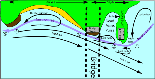
Here is one rowers’ advice on getting past the Bridge in a fast flood:

Rounding the North Tower: Hugging the corner of the North Tower
The basic idea is to stay out of the fast flood current whenever possible, which means staying close to the shore. The most challenging segment is likely to be under the Bridge as you pass the Tower. It is difficult for two boats to pass abreast of each other under the Bridge since the outside boat will enter fast current sooner and will swing out and fall behind. As you pass coves you should be able to pick up back eddies that will actually help you.
Steer wide of the east side of Lime Point but cut very close to the south tip as you pass.
Keep course for west corner of Bridge Tower wall.
Alcatraz will disappear behind Lime Point.
Row into first cove along the beach and follow any back eddy you can find.
Locate line of breaking surf and stay well outside it as you follow the beach.
Coming out of the cove stay close to rock cliff but outside wave reflections. Course should line up with the South Bridge Tower wall.
Hold Tower alignment halfway across the next cove and keep inside flood eddy line.
Beyond the Golden Gate Bridge: Penetrating a flood tide under the GG Bridge. The Open Ocean Regatta is on a Sunday in April, with rowers starting at 9 am on a flood tide. With all these constraints, some years the current under the Bridge will be quite strong.
The Open Ocean Regatta turns at Diablo Point, the first prominent point on the north side of the Golden Gate. The cove enclosed by Diablo is generally protected from the worst of the current and breeze.
If the weather and tides are especially favorable rowers can round Diablo to enter Bonita Nay and approach Bonita Point. Exposed to the open Pacific, this area can experience a large ocean swell and waves. This is not a place to be in a strong current, or any kind of ebb current.

Beyond the Golden Gate Bridge: A group row to Point Diablo